
 Palm Springs turned out to be a lovely choice for a month…wish we would have booked here even longer. The palms were among the highest we’ve ever seen and the population is less than 50,000, much smaller than we had anticipated. We had read that the weather could be cool but compared to Michigan we knew we’d find it enjoyable. As it turned out the weather was in the high 70’s and 80’s for the entire month we were there. Now that’s January weather I can get used to! We rented our Airbnb apartment from a guy who lives in New York and it was perfect. The two bedroom apartment was spacious, great cooking facilities, comfy bed, lots of stores were nearby and just a short drive from downtown. Couldn’t have been better!
Our apartment faced the pool with two chairs and a table on our balcony making it a perfect location for an afternoon glass of wine to go with our cribbage game. The complex was divided into eight separate units each with its own stairway which was covered by a profusion of bouganvilla.


One afternoon as Bob was sitting there reading he swatted what he thought was a fly away from his ear. How surprised he was when he realized it wasn’t a fly at all but a hummingbird!
One of the jaunts we enjoyed most was a side trip to San Diego. It’s about a two and a half hour drive through the mountains from Palm Springs and oh so beautiful.


Our route took us over the San Gorgonio Pass one of the windiest places in the US, and which acts as a wind tunnel between the coast and the Coachella Valley, so it was understandable that we would once again encounter the ubiquitous windmill. And wide-lane highways made it possible for even the driver to take in the sights!


Our first destination was the San Diego Zoo. It was warm and sunny, just as we would expect in San Diego, and we saw a baby giraffe, pandas, koalas, even a zoo medical assistant applying lotion to a flamingo’s feet because just like people their feet dry out in the desert climate.


We had made reservations to spend the night in San Diego so we could see a bit more of the area. We asked locals about suggestions for a seafood restaurant and Kings Fish House seemed to be the place. http://kingsfishhouse.com/. Yummy! Bob had the seafood platter and I had the fresh salmon and both were wonderful. But I was a bit surprised that the menu marketed my plate as British Columbia Atlantic Salmon. Hmm… Last I knew BC was on the Pacific!
We woke up the following morning to unusually warm weather and headed for the boardwalk in Coronado where we watched the surfers. Then headed back to Palm Springs travelling first up the Pacific coast to La Jolla where we strolled along the water enjoying the sun and surf just like the sea lions on the beach.


In August we had been in Seattle for the solar eclipse and were a bit disappointed by how little it affected the daylight, but on January 31 we were treated to a wonderful view of a lunar eclipse. We got up about 4:30 am, took our coffee outside, and had a seat on our balcony for an amazing show. For nearly an hour we watched as a shadow slowly covered the moon. Then much to our surprise, it quickly disappeared as the moon went down behind the mountain. We hadn’t anticipated that!


Another place on my “must see list” was the Salton Sea. We had captured glimpses of it from the interstate on our initial drive into Palm Springs. We were thrilled to find friends from Michigan were also visiting Palm Springs so we decided we’d make the trek together, about 60 miles. The Salton Sea is a really fascinating place. It’s 236 feet below sea level and located directly over the San Andreas fault.
The sea is only a little more than a hundred years old and was formed when the Colorado River broke through irrigation gates in Yuma, Arizona, and the entire area around the main line of the Southern Pacific Railroad community was flooded. This flooding went on for two years and wasn’t halted until 1907. Now the Salton Sea is the largest lake in California. In the 1950’s this was a big resort area; it has since deteriorated in large part due to the pollution of the lake. We encountered many dead fish as we walked along the beach.


And although we had read there is a stench associated with the sea, we didn’t find that to be the case. We also read that there are mud pots and mud volcanoes on the eastern shore but we didn’t see either. There are some unusual man-made sights, however. For instance, there’s a banana museum which was unfortunately closed. Hmm…and bananas don’t grow in California; well, at least aren’t commercially grown. Then there’s Salvation Mountain near Slab City. This mountain was the idea of Leonard Knight who constructed the mountain from adobe, straw, and lead free paint. The mountain is covered with biblical sayings. Hard to explain. You just have to see it!


Driving back we came upon the now all too familiar sight of border patrol checking cars driving north. They gave us a smile and waved us on. I can’t quite decide if this is racial profiling or credible security. 
Palm Springs is also about a 45 mile drive from Joshua National Park. I had seen where in the summer the temperatures can reach 115 degrees or more. Winter is definitely the time to visit.


The park is particularly interesting because two distinct deserts meet there. The northern part of the national park is in the Mohave Desert and much prettier, I believe, than the southern part of the park which is part of the Colorado Desert (part of the larger Sonoran Desert) and much more barren. We didn’t realize there was such a difference between the deserts. The Joshua Tree is a yucca and we were told seeing them is a good indicator that we were in the Mohave Desert and as we left the high desert and moved into the Colorado they indeed disappeared. (But later we were told some Joshua Trees do grow next to the saguaro in western Arizona. It gets confusing!) There is also an abundance of boulders which makes the park a favorite place for rock climbers!


We were lucky to be there on a clear day which made the stop at Keys View (in the northwestern part of the park) spectacular. Just as we walked to the top of the viewing area a ranger came up behind us and explained what we were looking at. We were standing at just over 5,000 feet. Wow! We could see Palm Springs, the San Andreas Fault and the Salton Sea.


He also explained that the small cut outs in the road, which I had assumed were for water runoff, provided a way for desert turtles to cross the road! And while we saw lots of cut outs we never sighted a turtle! We also liked the Cholla Cactus Garden.


We’ve seen other cactus gardens but this one is natural and wild. There’s a flat trail less than half a mile long that winds through it. I can only wonder how gorgeous it must be when it blooms! We didn’t encounter large crowds anywhere. Perhaps because we were there on Super Bowl Sunday? And with all our stops it was about a three hour trip through the park.
Time again to move on. As we began our trip back across country we decided we wanted to see Las Vegas. The drive there would take us a little over four hours across the high desert. We were reminded that we were entering desolate country when we came upon a sign indicating no services for the next 96 miles. The vast barrenness of the land is beyond description. As far as the eye could see…nothing… Then in the middle of no where we came upon a row of mailboxes, here in a place where we saw no evidence of a community. I can’t begin to imagine how self-sufficient you’d have to be to live here. Surprisingly, and perhaps reassuring, we regularly encountered vehicles traveling in both directions.


Las Vegas just appears! This huge mecca of entertainment seems to rise out of nowhere. Evidently Las Vegas really sprang to life in the 1930’s when Boulder (now Hoover) Dam was being built. We stayed at the Excalibur, and we walked down the steps, up the escalators along the strip and saw the famous fountain of the Bellagio, tried our hands at the slots in the Venetian. We took in a wonderful show that was a tribute to the Bee Gees. (And were flabbergasted at how old Bee Gees fans have become!) But after a day and a half we were ready to say enough and move on.


We drove through Lake Mead National Recreation area toward Hoover Dam.
")


The dam is amazing. It is truly hard to imagine how this massive project was ever moved from a vision to a reality. Then there’s the impact it’s had on the area. We forget that it’s created recreation areas, provided hydro electricity and irrigation. American ingenuity at its best! We also had to stop at Lake Havasu. Really London Bridge in Arizona? We were surprised by how very beautiful it is and how natural it seems in the desert environment.

")
The forecast continued to be good so we decided we could take a shorter, more northern, route east as we headed for our next stop North Carolina. We spent the night in Flagstaff, elevation 6900 ft, and asked our waiter at dinner if this 50 degree weather were typical for this time of year; he shook his head and said last year at this time they had a foot and a half of snow. As a snowboarder he was pretty frustrated, but added that it looked like in a week they should get some snow. Great! We’d be far far away by then!
The next morning we continued our drive through the desolate west. We stopped in Winslow Arizona, to see the construct of the Eagles’ “Standin on a Corner.”


Then we stopped at the Painted Desert and the Petrified Forest spending little time there as we remembered both from camping trips when our kids were young.  We felt like we were making progress as we crossed the Continental Divide just 25 miles east of Gallup, New Mexico. We’ve been surprised by the number of trains we’ve encountered throughout the west. And they’re long…often more than a hundred cars, mostly hauling containers. Can’t help but wonder where are they coming from? And where are they going?
")


Every so often we’ve seen sights that make us laugh right out loud.


And we were always on the look out for a place of historical significance. So when we came to Fort Smith, Arkansas, we had to stop. Fort Smith was established in an attempt to restore law and order to the area. Under the Indian Removal Act the Cherokee Indians were forced to move onto lands of other tribes, and not surprisingly the other tribes, in this case the Osage, objected. Disputes arose between the tribes as well as between the tribes and greedy businessmen who wanted the land.
The visitor center provided a lot of information about the disputes and how as the frontier moved westward, the fort was changed to the site of a federal court. An interesting character, Judge Isaac Parker–often referred to as “the hanging judge”–presided over the court for 21 years. During his tenure 86 men were hanged for murder or rape and once sentenced had no right of appeal. The jail was one large room where all prisoners lived together. One can only wonder how that worked out!
One of the Osage leaders was Chief Bad Tempered Buffalo–wouldn’t those sorts of names be helpful in the professional world of today? Particularly in education? They could give us some sort of preview of what communication issues may arise. Think of it: as an elementary principal I could have been called Chief Bad Tempered Tall Woman. I think it has real possibilities.
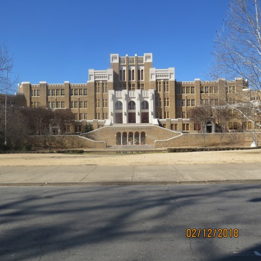
 But the greatest stop for me was the Central High School Historic Site in Little Rock, Arkansas. The school is spectacularly beautiful with stunning architecture. The high school (grades 9-12) still operates with an enrollment of about 3,000. Since we had stopped here in 2008 they’ve constructed a visitors center commemorating the integration of the high school in 1957.
Looking at picture books I came upon a story I had never heard. The book, Ruth and the Green Book, by Calvin Alexander Ramsey, tells the story of a family traveling south from Chicago and how they are given The Green Book describing for them restaurants, gas stations and motels where they could safely stay. While the story is fiction, the guide book is not. It was written by Victor Hugo Green, a New York City postman. It was published annually from 1936 – 1966. 1966!!! Unbelievable!
 We came upon an exhibit that shows the literacy test that Blacks had to pass in order to be able to vote. I wonder how many Americans could pass that test today! The ranger asked if we had any questions and I think he was surprised when we responded that no, we both could remember the event. We then drove to the Capitol to see a sculpture of the nine very brave students who on that day in 1957 made such a difference for the future of so many! How far we’ve come! How far we’ve yet to go!

Moving on to Tennessee the landscape changed dramatically becoming much more lush. Yep, we were definitely in the east…we entered the eastern time zone, crossed the Appalachian Trail! And finally we crossed into North Carolina, the state that will be our home for the next two months.


We managed to drive across country twice, in November and again in February, avoiding bad weather! I’m not sure I even thought it was possible. Once again we are feeling VERY lucky! And while technically we hadn’t driven “from sea to shining sea” we started out just 100 miles from the Pacific and 10 days later we’re just 130 miles from the Atlantic! We’ve traveled a distance of 2707 miles! Wow! After spending so much time in Europe in the past few years, we are reminded of just how vast and diverse our country is!
